In CivilGEO’s software, the user can control various settings at the application and project levels which can be used for modeling a project. These settings can be viewed and modified from the Options backstage page under the File ribbon menu.
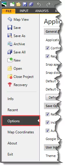
The Options backstage page is further divided into Application Options and Project Options sections.
The below sections of the article describe different subsections of the Application Options and Project Options sections.
Application Options
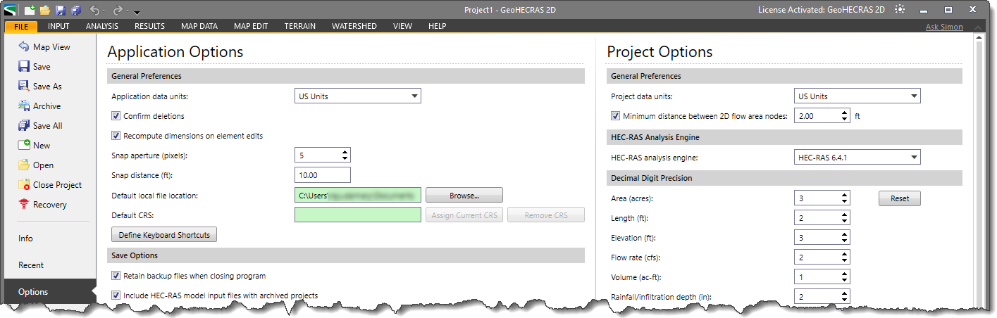
This section of the Options backstage page allows the user to control various application-level settings of the model. The changes made in the Application Options section change the overall settings of the project at the application level. The changes made in the settings under this section will always be applied by default to the project when it is prepared.
The different subsections under the Application Options section are as follows:
General Preferences
The options under this subsection are common to both GeoHECRAS and GeoHECHMS:
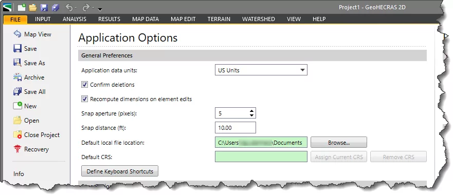
The different options under the General Preferences subsection are as follows:
- Application data units
This dropdown combo box entry allows the user to set the application data units either in US or metric units.
- Confirm deletions
If this checkbox entry is checked, then the application will always prompt the user to confirm the deletion of the project element(s).
- Recompute dimensions on element edits
If the user edits any of the model element while keeping this option checked, the software will then automatically recompute the dimensions of the edited element.
- Snap aperture (pixels)
This entry allows the user to specify the size of the Snap aperture in pixels. Using this option, the software automatically snaps to the nearest adjoining complementary object within its snapping aperture.
- Snap distance
This entry allows the user to specify the snapping distance (i.e., radial distance) used by the software to automatically snap to the nearest HEC-HMS element within the set snap distance or range.
- Default local file location
This read-only field displays the default local file locations. Clicking the adjacent [Browse] button allows the user to modify the folder location to save the files.
- Default CRS
This read-only field displays the information of the default project CRS applied by the user. Clicking the adjacent [Assign Current CRS] button automatically assigns the CRS of the current project as the default CRS. Clicking the [Remove CRS] button removes the applied CRS.
To learn more about the coordinate reference system (CRS), refer to
this article in our knowledge base.
- Define Keyboard Shortcuts
Clicking the [Define Keyboard Shortcuts] button displays the Keyboard Shortcuts dialog box where the user can edit or assign keyboard shortcuts for any command.
To learn more about the customization of keyboard shortcuts, refer to
this article in our knowledge base.
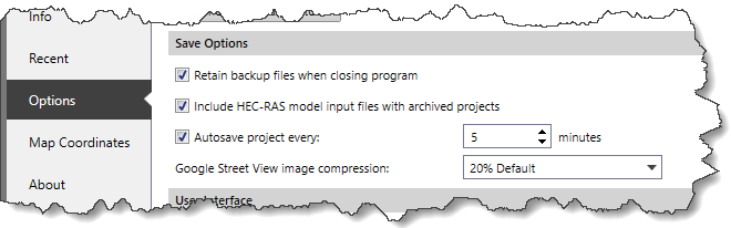
Save Options
The options under this subsection are common in both GeoHECRAS and GeoHECHMS.
The different options under the Save Options subsection are as follows:
- Retain backup files when closing program
If this option is checked, then the software creates and retains the project’s backup file. If this option is unchecked, then closing the program automatically deletes the existing backup file from the project folder.
- Include model input files with archived projects
If this option is checked, the software will include input files with the archived project.
To learn more about project archiving, refer to
this article in our knowledge base.
- Autosaving project duration
The Autosave project every option allows the user to set the time interval at which the project will automatically be saved.
To learn more about project backup and autosaving, refer to
this article in our knowledge base.
- Google Street View image compression
This dropdown combo entry allows the user to compress the image size (in Percentage) captured from the Google Street View command.
To learn more about Google Street View image capturing, refer to
this article in our knowledge base.
User Interface
The options under this subsection are common to both GeoHECRAS and GeoHECHMS.
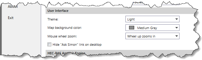
The different options under the User Interface subsection are as follows:
- Theme
This entry allows the user to choose from Light and Dark themes for the application.
- Map background color
This dropdown combo box entry allows the user to change the map background color with the available color options.
- Mouse wheel zoom
This dropdown combo box entry allows the user to select the behavior of the mouse wheel with respect to zooming within the application.
- Hide “Ask Simon” link on desktop
Checking this checkbox option hides “Ask Simon” AI enabled technical assistance link from the desktop.
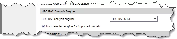
HEC-RAS Analysis Engine
This subsection allows the user to select which version should be used for the analysis computations. To learn more about HEC-RAS Analysis Engine subsection, refer to this article in our knowledge base.
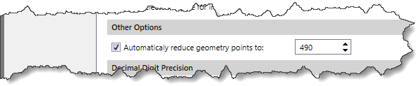
Other Options
In GeoHECRAS, the Automatically reduce geometry points to entry allows the user to automatically filter out unnecessary station-elevation points from project geometry. To learn more about geometry point reduction, refer to this article in our knowledge base.
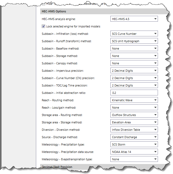
HEC-HMS Options
The options available under this subsection are as follows:
 Note that this subsection is available only in GeoHECHMS.
- HEC-HMS analysis engine
This dropdown combo box entry allows the user to select which HEC-HMS analysis engine version should be used for the analysis computations.
- Lock selected engine for imported models
This checkbox option causes the software to lock the selected HEC-HMS analysis engine for analysis computations in all imported models. By default, this checkbox is checked.
This subsection also provides the option to choose the default hydrology methods for different HEC-HMS elements.
- Subbasin Methods
The available subbasin methods are Infiltration, Runoff, Baseflow, Storage, and Canopy.
To learn more about these subbasin methods, refer to
this article in our knowledge base.
- Subbasin Results Roundup
In GeoHECHMS, the user can set the decimal digit precision for subbasins output results such as Impervious, Curve Number (CN), and TOC/Lagtime.
- Reach Routing Methods
The available routing methods are Kinematic wave, Lag Time, Lag Time & Attenuation, Modified Puls, Muskingum, Muskingum Cunge, Normal Depth, and Straddle Stagger.
To learn more about these reach routing methods, refer to
this article in our knowledge base.
- Reach Loss/Gain Method
The available reach loss/gain methods are Constant Loss/Gain and Percolation Loss. Note that the Percolation Loss method is only active when Modified Puls or Muskingum Cunge is selected as the reach routing method.
To learn more about
Reach Loss/Gain methods, refer to
this article in our knowledge base.
- Storage Area-Routing Methods
The available Storage Routing methods are Outflow Curve, Outflow Structures, and Specified Release.
- Storage Area-Storage Methods
- If Outflow Curve is selected as the Storage Routing method, the available Storage Methods will be Elevation-Area-Discharge, Elevation-Storage-Discharge, and Storage-Discharge.
- If Outflow Structures or Specified Release is selected as the Storage Routing method, the available Storage Methods will be Elevation-Area and Elevation-Volume.
- Diversion Methods
The available diversion methods are Constant Discharge, Inflow Diversion Table, Lateral Weir, Pump Station, and Time Series. To learn more about these diversions methods, refer to this article in our knowledge base.
- Source Discharge Methods
The available source discharge methods are Constant Discharge and Discharge Hydrograph.
- Meteorology Precipitation Types
The available precipitation types are Frequency Storm, HMR52 Storm, Inverse Distance Weighted, Rain Gage, Rainfall Distribution, SCS Storm, Specified Hyetograph, and Standard Project Storm.
To learn more about meteorology precipitation types, refer to
this article in our knowledge base.
- Meteorology Precipitation Data Source
This dropdown combo box entry is used to select a precipitation data source which can be used to retrieve the rainfall data for the selected storm frequency and storm duration. The dropdown entry provides the option to choose the precipitation data source for the USA, Austria, Ontario, and Germany.
- Meteorology Evapotranspiration Types
The available meteorology evapotranspiration types are Annual Evapotranspiration, Monthly Average, and User-Defined.
To learn more about meteorology evapotranspiration types, refer to
this article in our knowledge base.
Decimal Digit Precision
This section allows the user to set the decimal digit precision for various model variables. Note that the Decimal Digit Precision subsection is common for both the Application Options and Project Options sections.
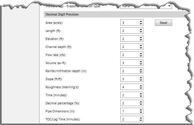
The software contains the following model variables:
| Decimal Digit Precision |
| GeoHECRAS Model Variables | GeoHECHMS Model Variables |
| Area | Area |
| Length | Length |
| Elevation | Elevation |
| Flow rate | Channel depth |
| Volume | Flow rate |
| Rainfall/Infiltration depth | Volume |
| Slope | Rainfall/Infiltration depth |
| Roughness (Manning’s) | Slope |
| Time | Roughness (Manning’s) |
| Time |
| Decimal Dimension |
| Pipe Dimension |
| TOC/Lag Time |
Clicking the [Reset] button resets the decimal digit precision to default values.
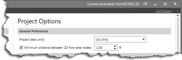
Project Options
This section of the Options backstage page allows the user to control various project-level settings of the model. The changes made in the Project Options section change the overall setting at the project level. The changes made in the settings under this section are temporary and change automatically according to the settings applied to the project.
The different subsections under the Project Options section are as follows:
General Preferences
- Project data units
This dropdown combo box entry allows the user to set the data units either in US or metric units. To learn how to set model units, refer to this article in our knowledge base.
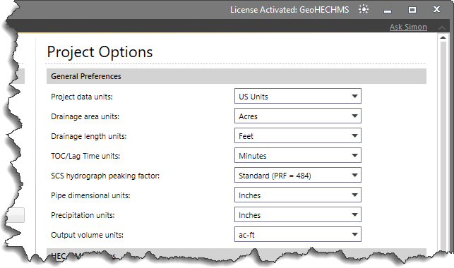
- In GeoHECHMS, the user can change units of various model variables. The units of these model variables changes as per the applied Project data units as shown in the following table.
| Model Variable | US Units | Metric Units |
| Drainage area | Acres, Feet2, Miles2 | Hectares, Kilometers2, Meters2 |
| Drainage length | Feet, Miles | Kilometers, Meters |
| TOC/Lag Time | Hours, Minutes | Hours, Minutes |
| SCS hydrograph peaking factor | The SCS hydrograph peaking factor controls the volume of water on the rising and recession limbs. By default, the Standard (PRF=484) option is selected. |
| Pipe dimensional | Inches, Feet | mm, cm, Meters |
| Precipitation | Inches | mm |
| Output volume | ac-ft, ac-in, ft3 | 1000m3, m3 |
- In GeoHECRAS, there is an option to modify the Minimum distance between 2D flow area nodes. To learn more about 2D flow area nodes, refer to this article in our knowledge base.
HEC-RAS Analysis Engine
To learn more about this subsection, refer to this article in our knowledge base.
HEC-HMS options
This subsection and its underlying model variables are similar to the Application Options sections.
Decimal Digit Precision
This subsection and its underlying model variables are similar to the Application Options sections.


