
Welcome to CivilGEO Knowledge Base
Welcome to CivilGEO Knowledge Base
The Geospatial Data Abstraction Library (GDAL) is a computer software library for reading and writing raster and vector geospatial data formats. The Hierarchical Data Format (HDF) is a data model, file format, and I/O library designed for storing, exchanging, and managing complex data including scientific, engineering, and remote sensing data. The latest HDF5 format allows the user to handle GDAL’s raster and vector geospatial data formats.
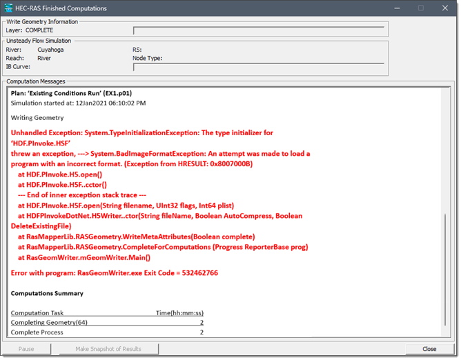
While loading GeoHECRAS or running an analysis of the HEC-RAS project, the user might encounter an uncommon error associated with GDAL or HDF5 project library files. Typically, this error occurs due to an outdated version of project libraries and their dependencies located in an incorrect system pathway.
 It is common for multiple versions of the same dynamic-link library (DLL) to exist in different file system locations within an operating system (OS). You can control the specific location from which any given DLL is loaded by specifying a full path. However, if you do not use that method, then the system searches for the DLL at load time.
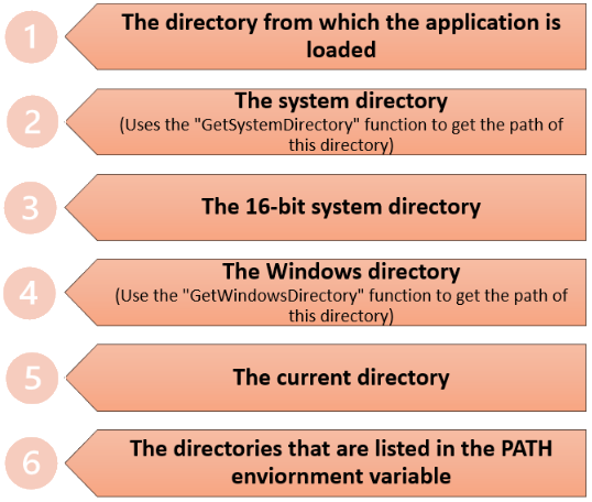
The Windows operating system strictly manages the dynamic-link libraries (DLLs) search order for security concerns related to potential computer viruses. This search order is outlined in the operating system’s hierarchy, as shown below.
Unlike most software that associates all required project libraries in a single directory, GeoHECRAS uses a combination of modern and legacy code. To accommodate both 32-bit and 64-bit functionalities, separate directories for different versions of identical files are essential. Therefore, GeoHECRAS maintains bin32 and bin64 subfolders within the primary software installation, as well as bin32/bin64 directories within our GDAL folder. To ensure that the correct files are accessed, GeoHECRAS modifies the PATH environment variable at runtime for the active GeoHECRAS process exclusively, preventing adverse effects on other system operations.
However, adding these directories to the PATH constitutes the 6th search order, replaced by the 2nd and 4th DLL search order, as shown above. In certain instances, other programs incorrectly place their installed DLLs directly into these directories, hindering the use of different (newer) versions by other software.
To rectify the file dependencies issue, identifying and uninstalling the conflicting software can be challenging. In addition, diagnostic steps requiring administrator privileges on the local machine can help in this process. In regards to this issue, the directories of concern are:
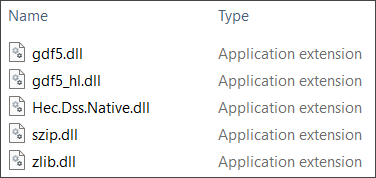
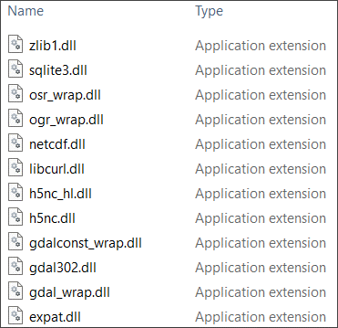
While the potential file conflicts can vary, you may inspect the following directories for the DLL files created on installing GeoHECRAS, as shown below:
C:\Program Files\CivilGEO\Shared\HDF\1.10.6.1\bin32
Or
C:\Program Files\CivilGEO\Shared\HDF\1.10.6.1\bin64
 C:\Program Files (x86)\CivilGEO\GeoHECRAS\HEC-RAS Engines\6.4.1\GDAL\bin32
Or
C:\Program Files (x86)\CivilGEO\GeoHECRAS\HEC-RAS Engines\6.4.1\GDAL\bin64
 The presence of the above-mentioned DLL files in the system directories is likely to conflict with certain GeoHECRAS processes.
If the initialization error of the GDAL path variables persists while using GeoHECRAS or during HEC-RAS analysis, the following measures can be taken to troubleshoot the situation:
Access the settings or preferences related to GDAL within the GeoHECRAS software. Verify that the path specified for GDAL is accurate and matches the actual location of the GDAL installation on your system. Reconfigure the path if necessary.
Consider reinstalling GeoHECRAS software or updating it to the latest version. Sometimes, software updates can fix known issues related to environment variables. This step is crucial if the current GDAL installation is outdated or if errors persist despite previous software installations. Refer to this article in our knowledge base for more information.
Perform a system restart after making any changes to the GDAL configuration. Sometimes, a reboot can resolve configuration-related issues by allowing the changes to take effect.
Note that the specific steps for resolution may vary based on individual system setups and the underlying cause of the error. If you are still having problems with this issue, contact our technical support. They will be glad to assist you further.


CivilGEO G2 Reviews
4.8/5.0 Rating, Over 230 Reviews

GeoHECRAS is recognized as the top Civil Engineering Design Software with an average of 4.8 out of 5.0 rating from over 230 real user reviews on G2.


We use cookies to give you the best online experience. By agreeing you accept the use of cookies in accordance with our cookie policy.
When you visit any web site, it may store or retrieve information on your browser, mostly in the form of cookies. Control your personal Cookie Services here.


