
Welcome to CivilGEO Knowledge Base
Welcome to CivilGEO Knowledge Base
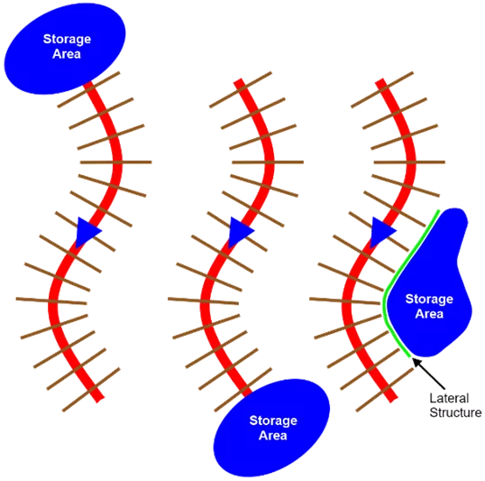
Upstream and downstream boundaries of a river reach can be connected to a reservoir, lake, or other types of large water bodies. These water bodies are called storage areas in HEC-RAS. In addition, off-channel ponding areas that exchange water with the adjacent river can be modeled as storage areas. A lateral structure is required to exchange water between the river and the storage area. Off-channel storage areas are important parts of hydraulic modeling that can be used for understanding rivers and floods. The following diagram represents the three different situations where a storage area can be connected to a river reach.
These storage areas are also important for figuring out flood risks and optimal water management strategies. This article explains how rivers can be connected to off-channel storage areas using lateral structures, which facilitates the understanding of flood events and associated water planning.
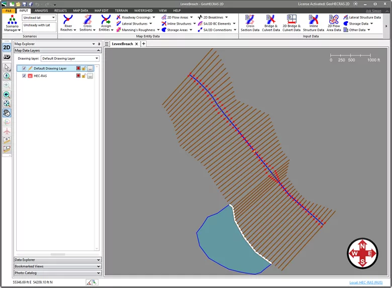
Typically, lateral structures and storage areas are used in unsteady flow modeling, where quantification of storage and hydrograph attenuation is very important. However, it is possible to use lateral structures and storage areas while doing steady flow modeling. The following project shows how a lateral structure can be used to connect a river to an off-channel storage area.
Before starting to connect rivers to the storage area using lateral structures, the modeler should ensure that all the required cross sections are correctly defined in the project. In GeoHECRAS, The Draw Cross Sections command enables the user to draw a cross section on the Map View as well as extract the cross section geometry from the underlying ground terrain. Alternatively, The Assign Cross Sections command can be used to select an existing polyline on the Map View, assign it as a cross section, and have the software extract the cross section geometry from the underlying ground terrain.
Notes:
Once the cross sections are correctly defined in the project, the user can draw a storage area interactively on the Map View or assign the already imported GIS shapefiles as a storage area. Refer to this article in our knowledge base to learn how to define HEC-RAS storage areas.
Once the required HEC-RAS elements such as cross sections and storage areas are defined, lateral structures can also be drawn/assigned to the project. The lateral structure is used to model flow being transferred between a river and adjacent elements, such as another river, storage area, or 2D flow area. The lateral structure acts as an internal boundary element between the above model elements and can represent a levee or flood wall, a flow diversion structure, or the natural terrain. The lateral structures are stationed from upstream to downstream river stations. In GeoHECRAS, the user can draw lateral structures interactively on the Map View or assign the already imported GIS shapefiles as a lateral structure.
While adding the lateral structure to the river reach, GeoHECRAS provides the user the option to link the lateral structure to another river reach, a storage area, or a 2D flow area. In this case, the user would choose to link a lateral structure to a storage area. Refer to this article in our knowledge base to learn more about the Draw Lateral Structures and Assign Lateral Structures command.
After the lateral structure is drawn/assigned, the Lateral Structure Data command can be used to define the properties associated with the lateral structure such as connection data, overflow weir, levee breach, etc. Refer to this article in our knowledge base to learn more about the Lateral Structure Data command.
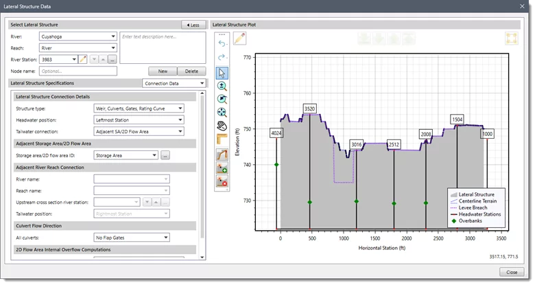
The headwater river station for a lateral structure is another important parameter because it helps to define where the lateral structure is spatially within the reach. This allows more accurate modeling and prediction of water flow and behavior. The user can specify whether the headwater position is on the right bank, on the rightmost station, on the left bank, or on the leftmost station. This flexibility enables precise placement of the lateral structure, which can be crucial for accurate modeling and simulation.
A tailwater connection is one of the important connection parameters for a lateral structure that refers to the way water interacts or connects with the downstream end of the structure. This connection is important because it influences how water flows through the structure and affects the overall hydraulic behavior of the system. The tailwater connection can significantly impact the efficiency and effectiveness of the lateral structure in managing water flow, especially in terms of controlling floods or regulating water levels. Proper tailwater connections are essential for ensuring the optimal functionality and performance of lateral structures within a water management system.
In the Lateral Structure Data dialog box, make sure that the Tailwater connection dropdown entry selection is set to Adjacent SA/2D Flow Area. Alternatively, you can connect a lateral structure to the adjacent river reach or out of the system (i.e., send the flow over/through the lateral structure out of the system).
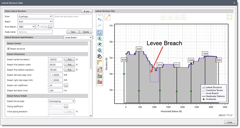
Levee overtopping and breaching can be analyzed within GeoHECRAS by modeling the levee as a lateral structure. When modeling a levee with a lateral structure, the area behind the levee (tailwater side) should not be included in the cross section data of the main river. The cross sections should stop at the top of the levee. The lateral structure (levee) can be connected to a 2D flow area, a storage area, or another river reach. The strategy for modeling the area behind the levee will depend upon what will happen to the water if the levee overtops or breaches. If the water going over or through the levee is likely to take many flow paths and have varying water surface elevations, then a 2D flow area is probably the most appropriate for modeling the area behind the levee. If the water going over or through the levee will fill the level pool water surface, then a storage area would be the most appropriate for modeling the area behind the levee. If the water will continue to flow in the downstream direction (and act like a separate 1D channel), and possibly reconnect with the main river, then it may be more appropriate to model that area as a separate river reach. The below diagram shows a levee modeled as a lateral structure connected to a storage area to represent the area behind the levee.
An overflow weir in lateral structures is a crucial component in modeling lateral flows. It is the part of the structure where the flow passes over. The weir type, which can be broad crested, sharp crested, ogee, or zero height, determines the amount of head loss that the flow encounters as it flows over the structure. Note that when defining a lateral structure, the lateral flow can discharge into an adjacent river, storage area, or 2D flow area. Refer to this article in our knowledge base to learn how to define overflow weir data using the Lateral Structure Data command.


CivilGEO G2 Reviews
4.8/5.0 Rating, Over 230 Reviews

GeoHECRAS is recognized as the top Civil Engineering Design Software with an average of 4.8 out of 5.0 rating from over 230 real user reviews on G2.


We use cookies to give you the best online experience. By agreeing you accept the use of cookies in accordance with our cookie policy.
When you visit any web site, it may store or retrieve information on your browser, mostly in the form of cookies. Control your personal Cookie Services here.


