
Welcome to CivilGEO Knowledge Base
Welcome to CivilGEO Knowledge Base
In fragment inundation, the hydraulic parameters between two cell centers are based on the higher of the two neighboring water surface elevations. An average between the two cell center elevations makes more sense hydraulically. But computationally, this can cause problems, particularly if there is an inflection (i.e., high ground) over the length between the cell centers, which could result in a water surface elevation lower than the lowest ground point in the 2D cell face. This produces a small amount of error, particularly in steeper terrain, but is not the reason for fragmented inundation.
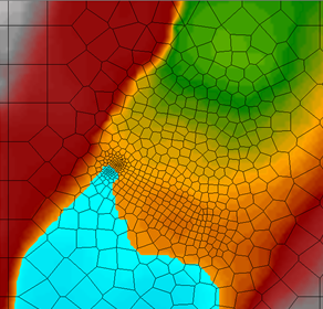
The HEC-RAS project results use a single water surface elevation computed per 2D cell. Normally, with sufficient water depths, this would go unnoticed. However, when water first enters a portion of a 2D flow area, depths are very low, and fragmentation may show up initially, especially if the terrain is steep and the cell size is relatively large. See the following diagram of a 2D mesh where 2D cells are too large on a steep slope.
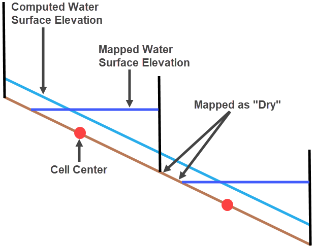
As shown in the above diagram, there are two neighboring cells with water flowing from left to right over steep terrain. The computed water surface elevation is a graphical representation of how the conservation of momentum and continuity equations are solved. In reality, the 2D cell face hydraulics are based on the water surface elevation from the upper cell center and the depth difference between the mapped water surface elevation. The computed water surface elevation at a cell face can be considered a schematization error. However, computationally, a water surface gradient is realized between the 2D cell centers, but when plotted, a single average water surface elevation is used for the entirety of each 2D cell. If the depth is too low, the modeler will notice dry portions in between wet portions, resulting in fragmented inundation. See the following terrain with smaller 2D cells.
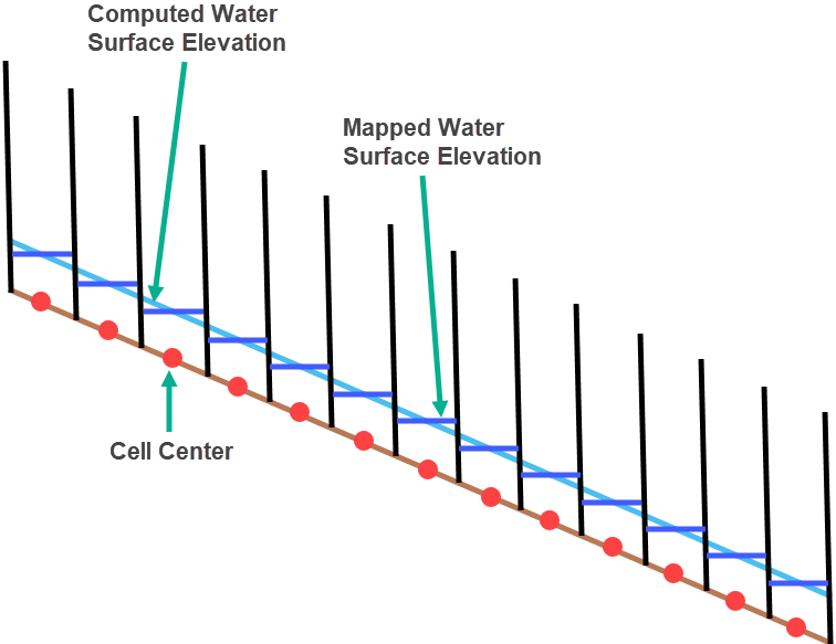
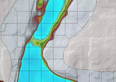
With the smaller 2D cell size, each 2D cell will be completely wetted for the same computed hydraulic gradient, resulting in a smoother, more realistic-looking inundation map. Decreasing cell size helps to reduce or eliminate fragmented inundation and the schematization error associated with how cell face hydraulics are computed.
The modeler should first analyze the requirement of reducing the size of 2D cells to troubleshoot the affected 2D flow area. Note that computationally, a hydraulic gradient is still realized over the length between cell centers, even when the modeler observes the fragmented inundation. The visualized fragmentation shows how the GeoHECRAS computational scheme arrives at a single water surface elevation for a given 2D cell and plots the corresponding water surface elevation. If the modeler is interested in the maximum inundation, then eliminating fragmentation at the beginning of the flood event may not be necessary.
If fragmented inundation is observed while checking the inundation maps, the underlying terrain of the project should also be checked. Note that 2D mesh leaking is another serious mapping error that can look similar to the fragmented inundation.
In 2D HEC-RAS modeling, 2D mesh leaking is different from fragmented inundation. Leaking is an issue in the 2D mesh in situations where terrain features do not align properly with cell faces or when cells are too large, leading to incorrect results in flood simulations. As shown in the below diagram, a high-ground feature is overlapped by a large cell. In this scenario, GeoHECRAS preserves the underlying terrain on the cell faces, but the cell itself is resolved to a volume-elevation curve.
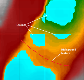
Because the high ground feature runs diagonally through the cell, GeoHECRAS does not recognize it as a barrier to water flow before it is overtopped. This results in water leaking through the high-ground feature prematurely. To address the leaking issue in 2D mesh, cell faces in the area of high-ground features should be aligned with the terrain to prevent leakage. By manually refining 2D mesh and aligning cell faces with high-ground contours, a higher-resolution flood map can be created that prevents leakage before overtopping.
Manually adding cell centers to align cell faces is imprecise and time-consuming. GeoHECRAS allows users to define breaklines along high-ground terrain features, which automatically generates 2D mesh, aligns cell faces with the defined breaklines, simplifies the process, and improves precision.
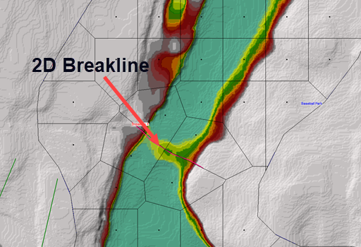
The 2D area breaklines in 2D HEC-RAS modeling are designed to address issues with leaking in 2D meshes, particularly when cell faces need to align with high-ground features, such as levees or berms, to properly represent the terrain in the mesh.
In 2D HEC-RAS modeling, the user is allowed to draw breaklines along the crest of high-ground features in topography, creating barriers to water flow. The breaklines help ensure that cell faces align with these high-ground features. As shown in the below diagram, there is a high-ground feature with an overflow section. If cell faces are not aligned properly, the model can allow flow to leak through the high-ground feature even before it is overtopped.
The user can select points on the schematic to draw breaklines, specify breaklines cell center spacing, and enforce the breaklines in the 2D flow area, as shown below.
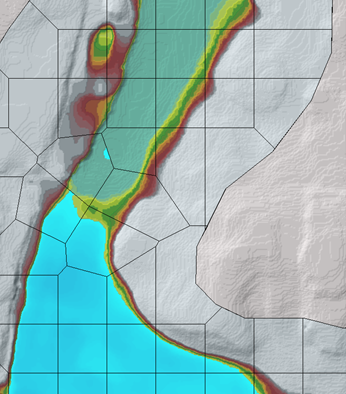
The use of 2D flow area breaklines ensures that high-ground features no longer leak, allowing water to pass only after overtopping occurs, as shown below.
There may still be some fragmentation downstream of the crest when water flows over steep terrain. The user can adjust cell sizes to address this issue but should consider the trade-offs based on the study objectives. Overall, 2D flow area breaklines offer a more efficient way to handle mesh alignment and reduce leaking in 2D models, enhancing the accuracy of flood simulations.


CivilGEO G2 Reviews
4.8/5.0 Rating, Over 230 Reviews

GeoHECRAS is recognized as the top Civil Engineering Design Software with an average of 4.8 out of 5.0 rating from over 230 real user reviews on G2.


We use cookies to give you the best online experience. By agreeing you accept the use of cookies in accordance with our cookie policy.
When you visit any web site, it may store or retrieve information on your browser, mostly in the form of cookies. Control your personal Cookie Services here.


