
Welcome to CivilGEO Knowledge Base
Welcome to CivilGEO Knowledge Base
The Hydroshed Data command of CivilGEO software allows the user to display the watersheds, lakes, rivers, streams, and subbasins data on the Map View.
The Hydroshed Data command retrieves its data from HydroSHEDS (Hydrological data and maps based on SHuttle Elevation Derivatives at multiple Scales) data store. HydroSHEDS provides hydrographic information in a consistent and comprehensive format for all parts of the world. The available data provides geo-referenced data sets (vector and raster) at various scales, including stream networks, watershed boundaries, drainage directions, and ancillary data layers such as flow accumulations, distances, and river topology information.
The HydroSHEDS data is derived primarily from elevation data of the Shuttle Radar Topography Mission (SRTM) at 3 arc-second resolutions. However, for all areas of the USA, the Hydroshed Data command bypasses the HydroSHEDS data store and provides more detailed and accurate information from the USGS NHDPlus HR (High Resolution) data store, which was developed by integrating the high-resolution National Hydrography Dataset (NHD) and Watershed Boundary Dataset (WBD) data with 3D Elevation Program (3DEP) 10-meter digital elevation model (DEM) data.
HydroSHEDS has been developed by the Conservation Science Program of the World Wildlife Fund (WWF), in partnership or collaboration with the U.S. Geological Survey (USGS); the International Centre for Tropical Agriculture (CIAT); The Nature Conservancy (TNC); the Government of Australia; McGill University, Montreal, Canada; and the Center for Environmental Systems Research (CESR) of the University of Kassel, Germany.
Follow the steps below to use the Hydroshed Data command:
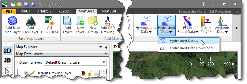
The following sections describe the Hydroshed Data command and how to interact with the above dialog box.
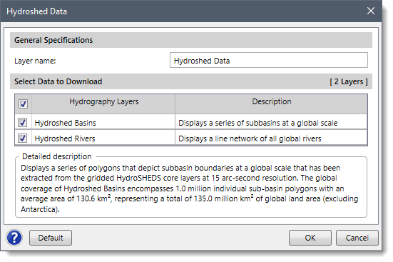
This section allows the user to provide a name for the layer group in the Layer name field. This name identifies the layer group that will be created in the Map Data Layers panel and will contain the downloaded Hydroshed layers. By default, the layer name is set to Hydroshed Data, which can be changed by the user.
The Select Data to Download section allows the user to choose the hydrography data layers that will be displayed on the Map View. In addition, every hydrography layer consists of a corresponding short description under the Description column. The user can use the provided default selection as these are typical options used. However, the user can experiment with the various options to customize which hydrography layers will be loaded and displayed on the Map View.
To return to the default settings, click the [Default] button.
After all the options have been defined, click the [OK] button, and the software will load and display the selected hydrography layers on the Map View.
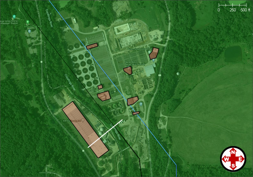
The software will then place the created hydroshed data layer in the Map Data Layers panel.
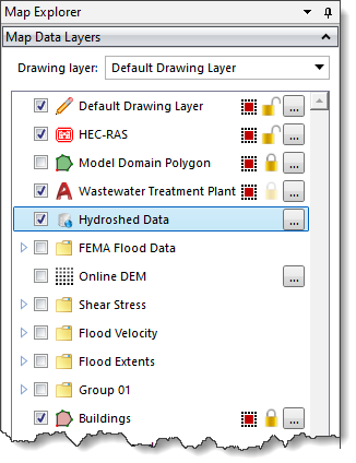
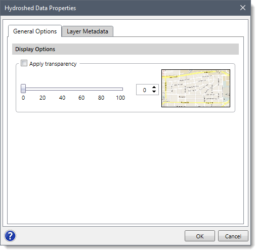
Clicking on the […] button adjacent to the created hydroshed data layer will display the Hydroshed Data Properties dialog box, which allows the user to change the image’s transparency and copy layer metadata text on the clipboard.
The Hydroshed Data dropdown menu contains one additional command: Hydroshed Data Download.
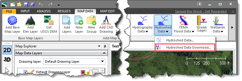 This command allows the user to download the watersheds, lakes, rivers, streams, and subbasins data as shapefile data. To learn more about this command, refer to this article in our knowledge base.


CivilGEO G2 Reviews
4.8/5.0 Rating, Over 230 Reviews

GeoHECRAS is recognized as the top Civil Engineering Design Software with an average of 4.8 out of 5.0 rating from over 230 real user reviews on G2.


We use cookies to give you the best online experience. By agreeing you accept the use of cookies in accordance with our cookie policy.
When you visit any web site, it may store or retrieve information on your browser, mostly in the form of cookies. Control your personal Cookie Services here.


