
Welcome to CivilGEO Knowledge Base
Welcome to CivilGEO Knowledge Base
It is quite easy to export a project to GIS shapefiles. The Export HEC-RAS to Shapefiles and Export HEC-HMS to Shapefiles commands allow the user to export current project elements and analysis results to ESRI shapefiles. This functionality allows project data to be shared with GIS and other software.
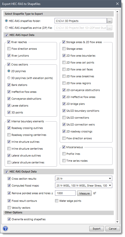
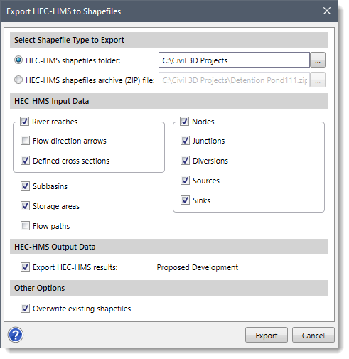
To export a project to shapefiles, select the Export HEC-RAS to Shapefiles or Export HEC-HMS to Shapefiles command from the Export Data dropdown menu of the Input ribbon menu. This will display the following dialog boxes:
The following sections describe how to interact with the above dialog boxes.
The Select Shapefile Type to Export section allows the user to select whether the GIS shapefiles should be saved into a directory folder or packaged together as a single ZIP compressed file.
Clicking on the […] browse button adjacent to the HEC-RAS shapefiles folder or HEC-HMS shapefiles folder radio button option allows the user to specify the directory location to export the GIS shapefiles.
Clicking on the […] browse button adjacent to the HEC-RAS shapefiles archive (ZIP) file or HEC-HMS shapefiles archive (ZIP) file radio button option allows the user to define the zip archive file for storing all GIS shapefiles.
Note: Saving the shapefiles in a .zip file makes it easier to share the shapefile data with other users and to archive the project.
This section allows the user to select which HEC‑RAS input data should be exported. The checkbox option at the HEC-RAS Input Data section header allows the user to enable or disable the section and its underlying elements to be exported. HEC-RAS elements that can be exported to a shapefile include cross sections, storage areas, 2D flow areas, internal boundary elements, river reaches, flowlines, nodes, etc. Each HEC‑RAS element type is placed in its own shapefile. For example, cross sections are placed in a cross-section shapefile, whereas river reaches are placed in a river reach shapefile.
This section allows the user to select which HEC‑HMS input data should be exported. HEC-HMS elements that can be exported to a shapefile include subbasins, river reaches, storage areas, junctions, sources, sinks, nodes, flow paths, etc. Each HEC‑HMS element type is placed in its own shapefile. For example, subbasins are placed in the subbasin shapefile, whereas storage areas are placed in the storage area shapefile.
This section allows the user to select which HEC‑RAS output results to export. The checkbox option at the HEC-RAS Output Data section header allows the user to enable or disable the section and its underlying elements to be exported. In addition, the user can select which flood map profiles to export; write out the water edge points (points at the edge of the main channel of the water) as a point file; and export flood map contours and 2D flow velocity arrows in a shapefile.
While exporting flood map results, the software removes ponded areas and holes with areas less than 1000 square feet from the exported results. However, the user can interactively measure the area from the Map View by clicking on the [Measure] button.
This section contains the Export HEC-HMS results checkbox. This checkbox option allows the software to export only the current scenario results. By default, this checkbox is selected when the dialog box is displayed.
Note: The current scenario name will be displayed next to the Export HEC-HMS results checkbox option.
This section contains the Overwrite existing shapefiles checkbox. This checkbox option allows the software to overwrite existing shapefiles with the same file name. By default, this checkbox is selected when the dialog box is displayed.
After the options have been defined, click the [Export] button and the software will export the project data to shapefiles.
Note that the cross sections are exported out as 3D polylines. These 3D polylines represent the 3D horizontal stationing and elevation of the cross section geometry.
Note: Only the current scenario (or plan) will be exported to shapefiles. Separate shapefiles will need to be created if multiple scenarios are to be exported.


CivilGEO G2 Reviews
4.8/5.0 Rating, Over 230 Reviews

GeoHECRAS is recognized as the top Civil Engineering Design Software with an average of 4.8 out of 5.0 rating from over 230 real user reviews on G2.


We use cookies to give you the best online experience. By agreeing you accept the use of cookies in accordance with our cookie policy.
When you visit any web site, it may store or retrieve information on your browser, mostly in the form of cookies. Control your personal Cookie Services here.


