Conveyance obstructions can be assigned to the 2D mesh to account for regions that are permanently blocked from conveying flow. Conveyance obstructions, such as buildings and other structures, decrease the flow area and add additional wetted perimeter where the water comes in contact with the obstruction.
2D conveyance obstructions are assigned using polygons. The software will automatically refine the 2D mesh to accommodate the conveyance obstruction shape.
2D conveyance obstructions can be defined using the following commands:
- Assign 2D Conveyance Obstructions
- Draw 2D Conveyance Obstructions
Assign 2D Conveyance Obstructions Command
If polygons have already been drawn on the Map View or a polygon shapefile layer has been loaded, the Assign 2D Conveyance Obstructions command can be used to assign 2D conveyance obstructions.
Follow the steps below to use the Assign 2D Conveyance Obstructions command:
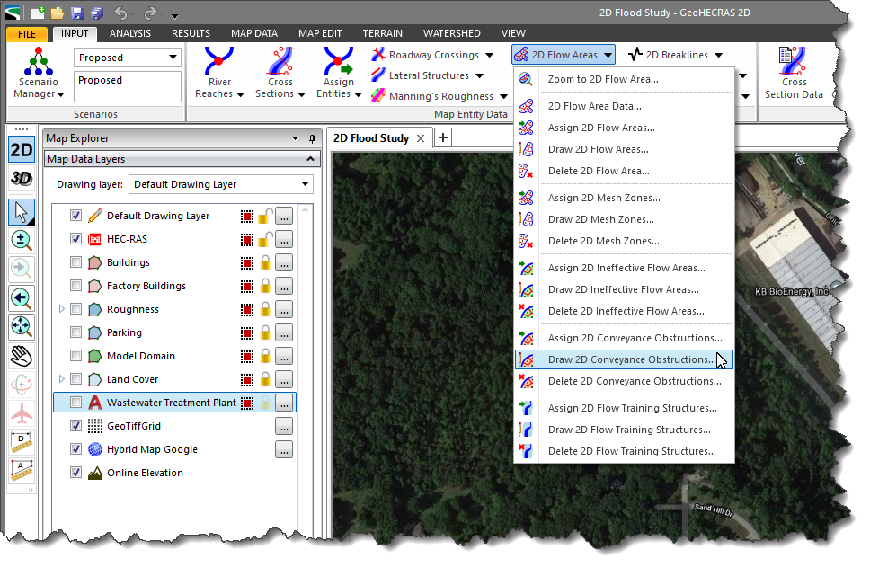
- From the Input ribbon menu, click the 2D Flow Areas menu item, and then select the Assign 2D Conveyance Obstructions command.
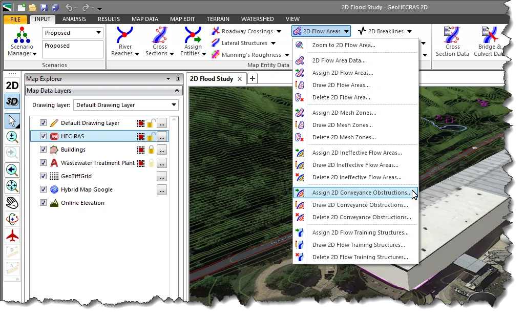
- The Assign 2D Conveyance Obstructions dialog box will be displayed.
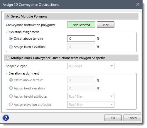
There are two options for assigning conveyance obstructions to 2D mesh:
- Select Multiple Polygons
- Multiple Block Conveyance Obstructions from Polygon Shapefile
The following sections describe how to use these assignment options.
Select Multiple Polygons
This option allows multiple polygons to be interactively selected from the Map View and then assigned as conveyance obstructions.
Follow the steps below to assign conveyance obstructions to 2D mesh using the Select Multiple Polygons option:
- Choose the Select Multiple Polygons radio button option. Then, click the [Pick] button.
![[Pick] button - Assign 2D Conveyance Obstructions dialog box](/wp-content/uploads/sites/25/2018/07/2D-Conveyance-Obstructions-image-5.png)
- The Assign 2D Conveyance Obstructions dialog box will temporarily disappear, and a prompt will be displayed on the status bar with next steps.
- Select the polygons on the Map View. Then, right-click and choose Done from the displayed context menu.
- The Assign 2D Conveyance Obstructions dialog box will be redisplayed.
- In the Elevation assignment section, select the desired option for assigning the conveyance obstruction elevation. Then, enter the elevation value.
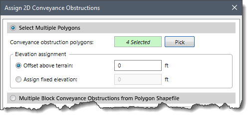
- Click the [OK] button. The selected polygons will be assigned as 2D conveyance obstructions.
Multiple Block Conveyance Obstructions from Polygon Shapefile
This option allows a polygon shapefile layer to be used to assign 2D conveyance obstructions.
Follow the steps below to assign conveyance obstructions to 2D mesh using polygon shapefile:
- Choose the Multiple Block Conveyance Obstructions from Polygon Shapefile radio button option.
- The software will display all loaded polygon shapefile layers in the Shapefile layer dropdown combo box. Select the corresponding shapefile layer.
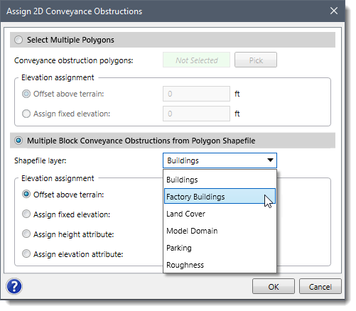
- In the Elevation assignment section, select the desired option for assigning the conveyance obstruction elevation. Then, enter the elevation value.
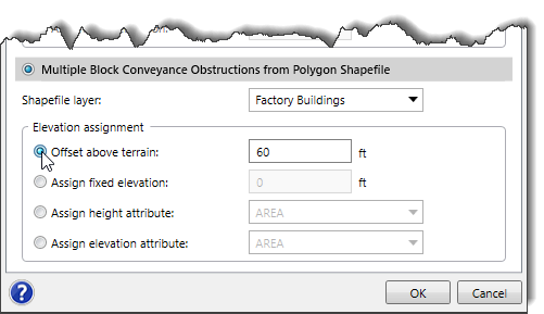
- Click the [OK] button. The selected polygons will be assigned as 2D conveyance obstructions.
![[OK] button](/wp-content/uploads/sites/25/2018/07/2D-Conveyance-Obstructions-image-9.png)
Draw 2D Conveyance Obstructions Command
The user can interactively draw polygons on the Map View in order to define the conveyance obstructions.
Follow the steps below to use the Draw 2D Conveyance Obstructions command:
- From the Input ribbon menu, click the 2D Flow Areas menu item, and then select the Draw 2D Conveyance Obstructions command.
- The Draw 2D Conveyance Obstructions dialog box will be displayed.
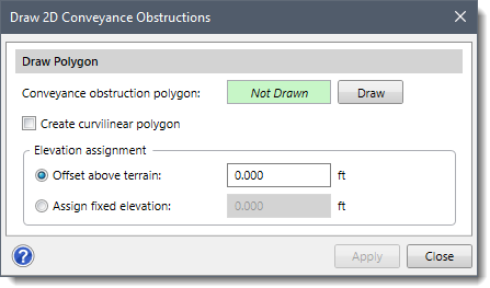
- Click the [Draw] button. The Draw 2D Conveyance Obstructions dialog box will temporarily disappear, and a prompt will be displayed on the status bar with next steps.
- Draw the polygon on the Map View.
Note: To draw the polygon using curvilinear segments, use Create curvilinear polygon checkbox option.
- After the polygon has been drawn, the Draw 2D Conveyance Obstructions dialog box will be redisplayed.
- In the Elevation assignment section, select the desired option for assigning the conveyance obstruction elevation. Then, enter the elevation value.
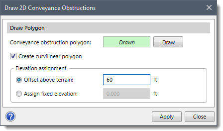
- Click the [Apply] button.
![The [Apply] button](/wp-content/uploads/sites/25/2018/07/Conveyance-Obstructions-Img-13.png)
- Repeat the process for all other buildings to be assigned as 2D conveyance obstructions.
Incorporating the Conveyance Obstructions into the 2D Mesh
After the conveyance obstruction polygons have been defined, the software will stamp them into the 2D mesh and refine the mesh to account for each polygon’s shape.
Follow the steps below to incorporate the conveyance obstructions into the 2D mesh:
- Double-click on the 2D mesh on the Map View to display the 2D Flow Area Data dialog box.
- Click the [Update] button and the software will incorporate the 2D conveyance obstruction into the 2D mesh.
![[Update] button - 2D Flow Area Data dialog box](/wp-content/uploads/sites/25/2018/07/2D-Conveyance-Obstructions-image-14.png)


