
Welcome to CivilGEO Knowledge Base
Welcome to CivilGEO Knowledge Base
The Horizontal Velocity Mapping command is used to define velocity mapping subareas on the cross sections that plot velocity fields for unsteady flow models. These subareas are used to compute more detailed velocity estimates within a cross section, rather than the default single average value in the left overbank, main channel, and right overbank. The flow elements (i.e., left overbank, main channel, and right overbank) are sliced, and the number of slices is entered for each flow element to further discretize the computation of average velocities within a cross section. These averaged velocities are used for mapping velocity within the 1D cross sectional flow fields.
Follow the steps below to use the Horizontal Velocity Mapping command:
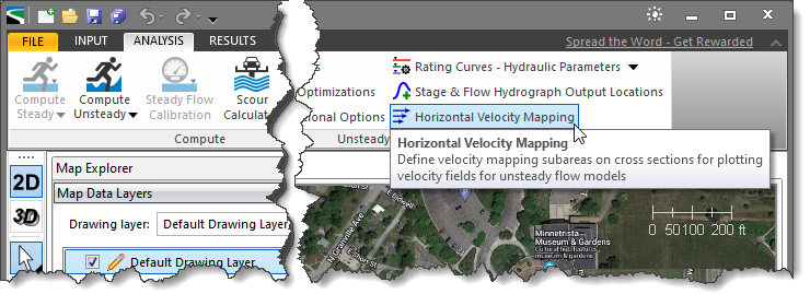
The following sections describe how to use the Horizontal Velocity Mapping command and interact with the above dialog box.
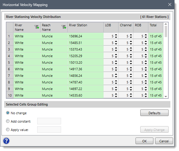
In this tabular section, the river name, reach name, and the corresponding river stations of the current project are displayed under River Name, Reach Name, and River Station columns. The user can enter the number of slices for each flow element (i.e., left overbank, main channel, and right overbank) under LOB, Channel, and ROB columns. By default, the software sets up five slices for each flow element. However, the user can alter these values as per modeling requirements. The number of total slices for each cross section is displayed under the Total column.
After selecting the preferred option, click on the [Apply Change] button to update the new values in the cells.
![[Apply Change] button](/wp-content/uploads/sites/25/2023/10/Horizontal-Velocity-Mapping-Command-Imag-3.png)
Note that clicking on the [Defaults] button will reset the number of slices to the default value (i.e., 5).


CivilGEO G2 Reviews
4.8/5.0 Rating, Over 230 Reviews

GeoHECRAS is recognized as the top Civil Engineering Design Software with an average of 4.8 out of 5.0 rating from over 230 real user reviews on G2.


We use cookies to give you the best online experience. By agreeing you accept the use of cookies in accordance with our cookie policy.
When you visit any web site, it may store or retrieve information on your browser, mostly in the form of cookies. Control your personal Cookie Services here.


