
The Georeference Inline Structures command allows the user to manually georeference each of the inline structures to the background base map displayed in the Map View. The process of georeferencing an inline structure to the Map View can be a trial and error process, especially when the exact location of the original inline structure is not known. With the use of the Georeference Inline Structures command, the georeferencing process can be accelerated.
Follow the steps below to georeference an existing inline structure:
- From the Input ribbon menu, click the Inline Structures dropdown menu and select the Georeference Inline Structures command.
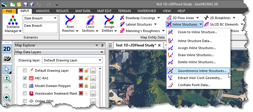
- The Georeference Inline Structures dialog box will be displayed.

The following sections describe how to georeference an existing inline structure and interact with the above dialog box.
Selecting Inline Structure to Georeference
The Select Inline Structure to Georeference section allows the user to select the inline structure to georeference.
Follow the steps below to select the inline structure to georeference:
- Select the river from the River dropdown combo box.

- Select the corresponding reach from the Reach dropdown combo box.
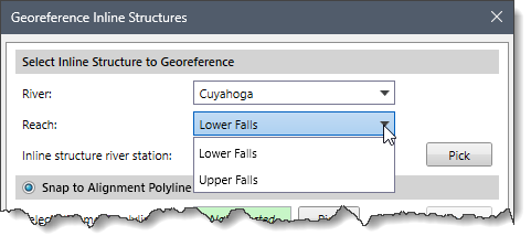
- Select the corresponding inline structure from the Inline structure river station dropdown combo box.
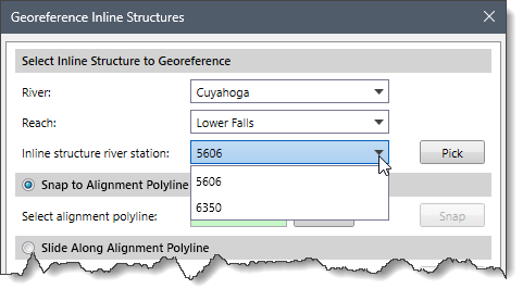
Alternatively, the user can interactively select the inline structure from the Map View. To select the inline structure from the Map View, follow the steps below:
- Click the [Pick] button adjacent to the Inline structure river station dropdown combo box.
![[Pick] button](https://knowledge.civilgeo.com/wp-content/uploads/2025/12/Georeferencing-Inline-Structures-Image-6.png)
- The Georeference Inline Structures dialog box will temporarily disappear, and a prompt will be displayed on the status bar instructing the user to select the inline structure to georeference.
- Select the inline structure on the Map View. Note that the user can select only one inline structure at a time.
- Upon selecting the inline structure, the Georeference Inline Structures dialog box will be redisplayed along with the inline structure river station value. The software will automatically select the corresponding river and reach in the River and Reach dropdown combo boxes.

Once the inline structure has been selected, the user can choose between the following options to georeference the inline structure:
- Snap to Alignment Polyline
- Slide Along Alignment Polyline
- Draw on Map View
Snapping Inline Structure to an Alignment Polyline
If an existing alignment polyline for the inline structure exists on the Map View, the Snap to Alignment Polyline georeferencing option can be used to snap the inline structure to the alignment polyline.
Follow the steps below to use the Snap to Alignment Polyline georeferencing option:
- Select the Snap to Alignment Polyline radio button option.
- Click the [Pick] button adjacent to the Select alignment polyline read-only field.
![[Pick] button](https://knowledge.civilgeo.com/wp-content/uploads/2025/12/Georeferencing-Inline-Structures-Image-8.png)
- The Georeference Inline Structures dialog box will temporarily disappear, and a prompt will be displayed on the status bar instructing the user to select the alignment polyline from the Map View.
- Upon selecting the alignment polyline, the Georeference Inline Structures dialog box will be redisplayed, and the status of the Select alignment polyline read-only field will be changed from Not Selected to Selected.

- After selecting the alignment polyline, click the [Snap] The software will then snap the selected inline structure to the alignment polyline.
![[Snap] button](https://knowledge.civilgeo.com/wp-content/uploads/2025/12/Georeferencing-Inline-Structures-Image-10.png)
Note: If the alignment polyline does not lie between the selected inline structure’s bounding cross sections, then the following informational dialog box will be displayed.
Sliding Inline Structure Along Alignment Polyline
If an inline structure has been snapped to an alignment polyline on the Map View but is not precisely located where it should be, the Slide Along Alignment Polyline georeferencing option can be used to slide the inline structure along the alignment polyline.
Follow the steps below to use the Slide Along Alignment Polyline georeferencing option:
- Select the Slide Along Alignment Polyline radio button option and click the [Slide] button.
![[Slide] button](https://knowledge.civilgeo.com/wp-content/uploads/2025/12/Georeferencing-Inline-Structures-Image-12.png)
- The Georeference Inline Structures dialog box will temporarily disappear, and a prompt will be displayed on the status bar instructing the user to select the inline structure and drag it along the underlying alignment polyline.
- Click and drag the inline structure on the Map View to revise its alignment.
- When finished, press the [Enter] key or right-click and select Done from the displayed context menu. The Georeference Inline Structures dialog box will be redisplayed, and the inline structure will be placed at the new location.
Notes:
- If the endpoints of the inline structure do not overlay the same continuous alignment polyline, then the following informational dialog box will be displayed.

- For more precision, the user can use the Snap to Alignment Polyline option first and then use the Slide Along Alignment Polyline option.
Drawing Inline Structure on Map View
The Draw on Map View option allows the user to draw an inline structure polyline on the Map View and automatically snap the selected inline structure to the drawn polyline.
Follow the steps below to use the Draw on Map View georeferencing option:
- Select the Draw on Map View radio button option and click the [Draw] button.
![[Draw] button](https://knowledge.civilgeo.com/wp-content/uploads/2025/12/Georeferencing-Inline-Structures-Image-14.png)
- The Georeference Inline Structures dialog box will temporarily disappear, and a prompt will be displayed on the status bar instructing the user to draw the inline structure polyline on the Map View.
- Draw the inline structure polyline on the Map View. When finished, press the [Enter] key or right-click and select Done from the displayed context menu.
- The Georeference Inline Structures dialog box will be redisplayed, and the inline structure will automatically snap to the drawn polyline.