
Welcome to CivilGEO Knowledge Base
Welcome to CivilGEO Knowledge Base
The Split Polygons command of CivilGEO’s software allows the user to split one or more selected polygons into separate polygons using a cut polyline. When splitting polygons, make sure the cut polyline intersects completely through the selected polygon.
Note that because the software defines the storage areas, subbasins, and 2D flow areas using polygon shapes, the Split Polygons command can be used to divide them even further into smaller subareas.
Follow the steps below to use the Split Polygons command:
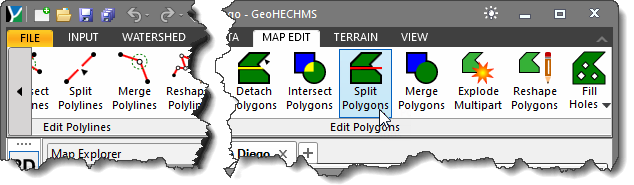
The following sections describe the Split Polygons command and how to interact with the above dialog box.
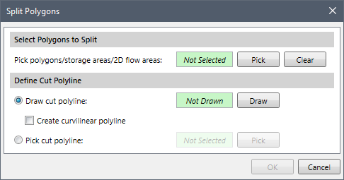
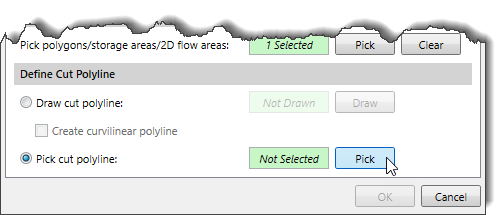
The Select Polygons to Split section allows the user to select the polygons to be split.
The user can click the [Pick] button to select the polygons (or other polygon shape elements) from the Map View. After selecting the polygons, the Pick polygons/storage areas/2D flow areas read-only field will display the number of selected polygons.
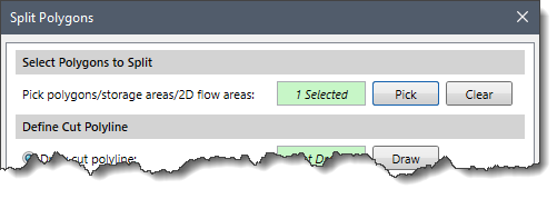
Alternatively, the user can preselect the polygons on the Map View prior to running this command. Upon running the command, the number of preselected polygons will be displayed in the Pick polygons/storage areas/2D flow areas read-only field.
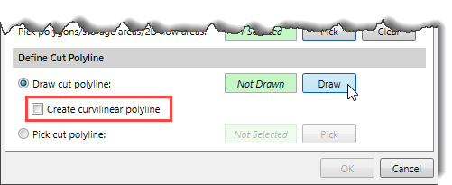
The Define Cut Polyline section allows the user to either draw or select an existing cut polyline from the Map View.
The following options are provided for defining the cut polyline:
The Draw cut polyline radio button option allows the user to interactively draw a cut polyline on the Map View.
Follow the steps below to draw a cut polyline on the Map View:
The Pick cut polyline radio button option allows the user to select an existing cut polyline from the Map View.
Follow the steps below to select a cut polyline from the Map View:
After the cut polyline has been defined, the user can click the [OK] button. The software will split the selected polygon(s) along the defined cut polyline.


CivilGEO G2 Reviews
4.8/5.0 Rating, Over 230 Reviews

GeoHECRAS is recognized as the top Civil Engineering Design Software with an average of 4.8 out of 5.0 rating from over 230 real user reviews on G2.


We use cookies to give you the best online experience. By agreeing you accept the use of cookies in accordance with our cookie policy.
When you visit any web site, it may store or retrieve information on your browser, mostly in the form of cookies. Control your personal Cookie Services here.


