
Welcome to CivilGEO Knowledge Base
Welcome to CivilGEO Knowledge Base
The Compute Reach Parameters command of GeoHECHMS allows the user to compute invert elevation, slope, length, and other parameters using reach alignment along the elevation terrain surface. These parameters are useful for quantifying the physical traits of reaches.
Follow the steps below to use the Compute Reach Parameters command:
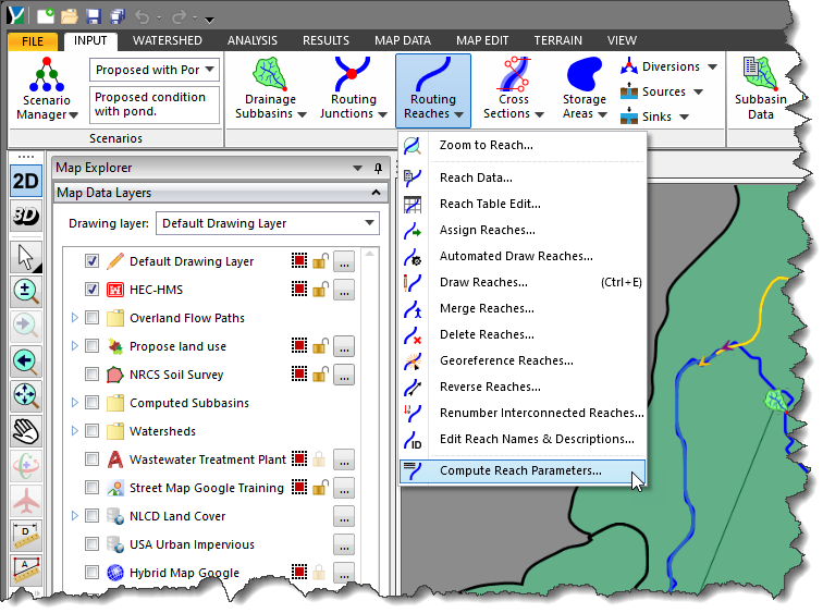
The following sections describe how to use the Compute Reach Parameters command and interact with the above dialog box.
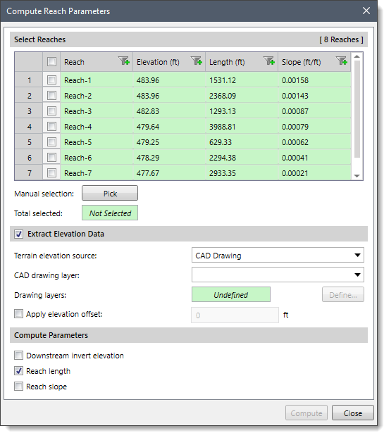
The Select Reaches section includes a table that lists all the reaches contained within the current scenario along with their elevations, lengths, and slopes.
This section is used to manually select reach(s) from the Map View. Clicking on the [Pick] button will cause the dialog box to temporarily disappear, allowing the user to select reaches from the Map View.
Upon returning to the Compute Reach Parameters dialog box, the total number of selected reach(s) will be displayed in the Total selected read-only field.
Note that the user can also preselect the reach(s) from the Map View prior to running this command. If the reach(s) were preselected on the Map View, the same reach(s) will be shown selected within the table.
This optional section is used to define the elevation data source to be used for extracting the reaches. Depending upon the elevation data source type that is selected, different options are provided to specify additional elevation data information.
Refer to this article in our knowledge base to learn more about the types of terrain elevation data that can be used to construct reaches.
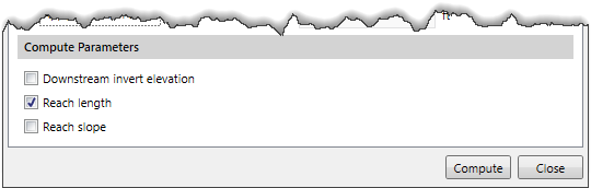
If the section checkbox is unchecked, then the Downstream invert elevation and Reach Slope options of the Compute Parameters section will be unavailable (i.e., grayed out). The software will only compute the reach length.
The user can also apply the elevation offset by enabling the Apply elevation offset check box entry. To lower the reaches for specific circumstances—a manhole bottom elevation, for example—define a negative offset value.
This section is used to compute the selected parameters for the reach. The Reach length checkbox is checked by default. The software automatically computes the reach length based upon the assigned polyline length.
Once the data has been defined in the Compute Reach Parameter dialog box, click the [Compute] button. The software will then look at each selected reach and compute the chosen parameters.


CivilGEO G2 Reviews
4.8/5.0 Rating, Over 230 Reviews

GeoHECRAS is recognized as the top Civil Engineering Design Software with an average of 4.8 out of 5.0 rating from over 230 real user reviews on G2.


We use cookies to give you the best online experience. By agreeing you accept the use of cookies in accordance with our cookie policy.
When you visit any web site, it may store or retrieve information on your browser, mostly in the form of cookies. Control your personal Cookie Services here.


