
Welcome to CivilGEO Knowledge Base
Welcome to CivilGEO Knowledge Base
A poor bridge location makes it susceptible to damage and a host of other problems. Therefore, the location for a bridge is as important as the characteristics of the bridge itself. Selecting a good bridge site involves several factors like environmental and geological concerns, hydrology and hydraulics, preliminary engineering and roadway alignment.

Generally, the location for a roadway crossing is selected during the planning and location phase of a highway project. The final location should be selected only after obtaining detailed survey information and completing a preliminary HEC-RAS hydraulic study. Although hydraulic criteria are not the sole consideration in bridge location and design, these issues should receive major attention in the initial planning of the highway. The location and alignment of the highway can either magnify or eliminate hydraulic problems at the crossing. Adverse conditions should be identified in the early stages of location selection so that potential problems receive adequate review and consideration. If the cost of the required structures is prohibitive, consider rerouting the highway.
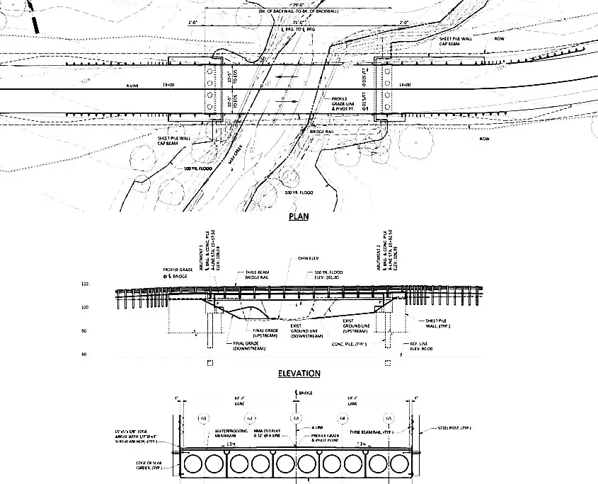
Bridges that are constructed in a poor location or that are the wrong size are more prone to failure. Therefore, it’s important to get the design and location right the first time. Good bridge siting involves many disciplines. A solid and effective analysis requires careful attention to preliminary engineering, hydrology and hydraulics, stream alignment, and environmental and geomorphic concerns. The specific hydraulic requirements are covered below:
Environmental impacts must be considered in conjunction with hydraulic issues given that one may directly affect the other.

During the course of site analysis and selection, biological considerations should include analyzing the effects of bridge construction on diverse habitat and ecosystems in the floodplain, stream, and associated wetlands. Biologists should evaluate this aspect of site selection and not only provide information necessary for a valid assessment of key biological effects but also address potential alternatives for mitigation, including the following:
Water resources development projects such as reservoirs or stream channel modifications, whether existing or projected for future development, must be considered when selecting a stream crossing location. Planned resources development projects often require the relocation or reconstruction of existing highways and can interfere with the location or design of proposed highway-stream crossings. Many water resources development projects are planned or authorized for several years or even decades before construction begins. Others never come to fruition or may be permanently stopped by court decisions or regulatory agency actions. The roadway designer must carefully plan and construct a highway near a water resources project location, designing the highway so that it is compatible with existing and future site conditions. The cost of building the roadway due to a projected or existing water resources project must be considered in selecting the stream crossing location.
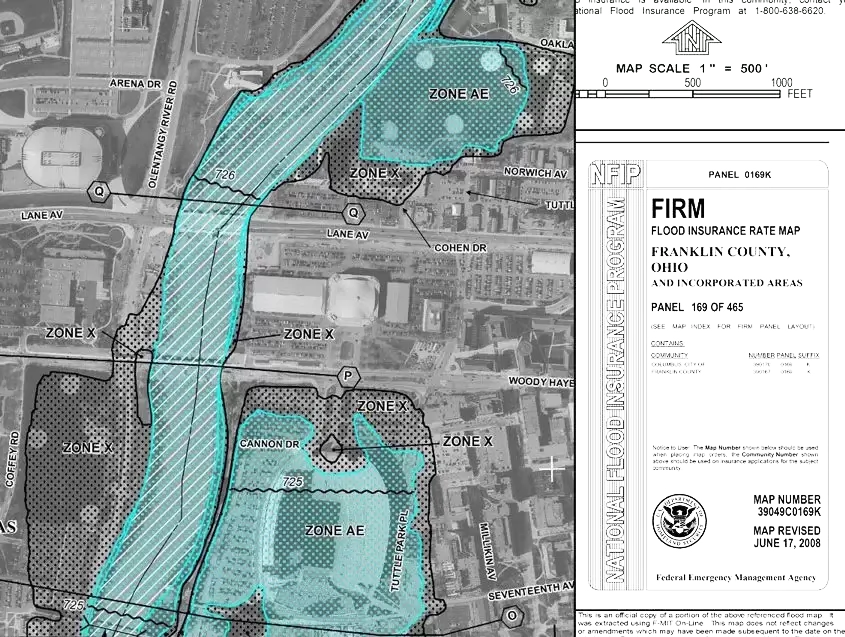
The majority of highway crossings involve floodplains that are in FEMA-participating communities. It is important to acknowledge FEMA floodplains in the planning phases of a project and accommodate them during the design process. Early coordination with the community’s NFIP administrator is essential to identify and avert potential problems.
All streams change with time. Planning, roadway and bridge design engineers should be conscious of stream morphology and be aware that methods have been developed to quantify natural changes and the changes that can occur as the result of stream encroachments and crossings.
Methods to analyze the hydrology and hydraulics at bridge sites continue to improve. In many cases, the methodology used in the original analysis is no longer the appropriate method to employ. The following steps should be used to examine the adequacy of the methodology:


CivilGEO G2 Reviews
4.8/5.0 Rating, Over 230 Reviews

GeoHECRAS is recognized as the top Civil Engineering Design Software with an average of 4.8 out of 5.0 rating from over 230 real user reviews on G2.


We use cookies to give you the best online experience. By agreeing you accept the use of cookies in accordance with our cookie policy.
When you visit any web site, it may store or retrieve information on your browser, mostly in the form of cookies. Control your personal Cookie Services here.


